The Klickitat Ape Cat

Not long ago a friend of mine asked the members in an online group chat if we’d ever heard of an ape cat. An ape cat? I’d never heard of it but it reminded me of something I’d heard from a guy I ran across a few years ago at a Squatchfest. He told me a story about an ape-faced panther-like creature he encountered once in a farmer’s field on the outskirts of nearby Ridgefield, Washington. He hadn’t used the term ape cat, but it sounded like something really similar.

My friend shared a link in the group chat to a podcast interview with a guy who claimed to have spotted one in Klickitat County, Washington. He owns an outdoor store that has since become an ape cat epicenter, having received some one hundred plus ape cat sighting reports. It was a fascinating interview, and he had some compelling ideas behind the origin of the creature. He’d even given it a name; the Klickitat Ape Cat. After listening to the podcast, I knew I needed to check out the store, and the story.

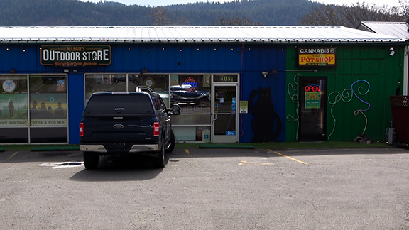
Margie’s Outdoor Store is a cool locally owned store in Bingen, Washington a small town nestled in the rocky hills along the Columbia River. It doubles as a sort of convenience store, camping outfitter, and a place for locals and tourists alike to report and discuss the weird things they encounter in the gorge. I decided to pay a visit and was pleasantly surprised with the friendly staff and lots of interesting inventory. Where else can you get a snicker’s bar, tarot cards, bag of chips and a sword all in the same purchase. It’s truly a one stop shop for those who appreciate the strange and unusual.

About eighteen miles east of Bingen is a steep-sided basalt mountain named Horsethief Butte. It overlooks nearby Horsethief Lake and is reported by some locals as an ape cat habitat. There’s a walking trail that loops around the hill beginning at a small parking lot. I surmise that if the ape cat does exist and if this is habitat there’s bound to be nesting areas around the butte. There would also be trails and signs of travel between the butte and the closest water sources which would include the Columbia River and Horsethief Lake.

Along the shore of Horsethief Lake is Horsethief Lake State Park which aside from some good camping, is also home to a fascinating collection of local native petroglyphs. I’ve been there several times to shoot still photos of the glyphs in different times of day. Interestingly enough, I’ve noted one of the glyphs seems to show the head of a mystical cat with an almost human or apelike face.

So what exactly is an ape cat? As far as I can tell it could be one of a few things. It’s either a mutant version of a panther, an extraterrestrial, a paranormal or mythical creature, or as the many critics say a clever marketing tool fabricated to boost local commerce. As you know, SteveSearches does not deal in conclusions but searches for evidence and lets the viewer decide.

As far as it being a mutant, it has been suggested in the related podcasts that the Klickitat Ape Cat could be a mutated fugitive from the Hanford nuclear site. Perhaps I’ll investigate this possibility in more detail in a future video.

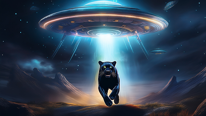
Like many of my research constituents I share a deep belief in the existence of extraterrestrials. In fact, it’s one of the few controversial ideas I openly and enthusiastically support. Considering the billions of stars in existence with their own planets, the belief we’re alone in the universe to me seems absurd. So far, I haven’t been on board with cryptids being extraterrestrial. I will admit though that lately I’ve been entertaining the possibility more than ever before. Considering recent video evidence and documentation becoming declassified it seems that yesterday’s conspiracy theories are becoming today’s realities. If this trend continues, and I believe it will, these will eventually become common knowledge.  So, is the ape cat an extraterrestrial being? I don’t know. What I do know is a question worth asking is worth looking into.

People that know me are aware of my lifelong interest in the paranormal, but when it comes to cryptids, I tend to first look for answers in the natural world. I took an anthropology class when I was in college and remember a fun conversation we had about the difference between natural and supernatural explanations. One example our instructor used as a natural explanation was the incredible hulk. The hulk character was a result of an accidental overdose of gamma radiation. True, he’s a fictional character but a mutant is not supernatural by definition and therefore falls inside the realm of the natural world. The idea of course was to demonstrate that many explanations can be natural and still be highly unconventional.

Mishipeshu is a powerful and often malevolent underwater panther-like creature described by indigenous people as having the head and paws of a giant cat. It’s commonly said to live near the Manitoulin Island in Lake Superior and is often associated with storms and death. Though the Mishipeshu originates in the Great Lakes area, similar mythical creatures can be found in the lore of many other places and cultures. Could locals and tourists visiting the Columbia Gorge be encountering a flesh and blood Mishipeshu?  It’s an interesting question that I believe will take more work to properly answer. I should note, however, I am not one to argue with people that have lived in these areas for twenty thousand or more years.

I haven’t found much information on ape cats in any other area of the country, so they seem isolated to the Columbia Gorge and maybe a few outlining areas. This fact could arguably lead to it being a marketing ploy but I’m personally not willing to come to this conclusion given I’m relatively new to this creature.

In the case of the ape cat, for me the jury remains out until a physical specimen or at least more solid evidence is discovered. In the meantime, I will continue to search for evidence and keep a watchful eye out for new sightings and information.

Watch the YouTube video.

The Case of Krystyn Dunlap

Note: THIS PROJECT IS ONGOING and more will be added to this post as future efforts continue.

Krystyn Dunlap was reported missing by her mother on October 16th, 1994. She was 17 years old at the time and was listed with National Crime Information Center (NCIC) and Missing and Unidentified Persons System as a runaway. In the following few months were sporadic reports from friends of having seen her as late as December of that year but she was never located by police or family members.

Her status was changed in 1998 from runway to missing person as she was now a legal adult. The case was revisited in 2011 with witnesses reinterviewed and databases re-examined but no new leads were found. The case remained cold but still open. By the summer of 2021 the case status moved from missing to most likely deceased.

I began studying the case during early summer of 2023. Earlier that year the family received new information on a possible search area and I was put in contact with the missing woman’s mother via a third interested party. In October 2023 I traveled to Boise with an assistant and mapped about a ten acre portion of the search area. We used a drone fitted with an 8k camera and captured around 120 images from an altitude of 250 feet. The images were then stitched together into a single composite image and used to create a comprehensive search map. We also created a 3D photogrammetric file of the landscape. The composite image and updated map was provided to the family and forwarded to the investigating agency. The map itself is an ongoing project and continues to be updated as further searches are conducted.

After closely reviewing the images and the 3D map for any anomalies, nothing notable was found. As of yet we haven’t heard back from the case detective. However, the area mapped is only a fraction of the search area and I anticipate returning for further flights. This will be most likely after the snow thaws in the spring and the ground is once again visible from the air.

Links:

National Center for Missing and Exploited Children

City of Boise January 2022 Article

City of Boise September 2023 Article

GoFundMe Page

Krystyn Facebook Page

LeRoy Haagen Memorial Community Park

This is a typical example of a map created using a drone. A map created using a drone shows a detailed view of the park, including greenery, the playground, and the walking paths. The map has a superimposed layer created in AutoCAD shown in cyan which makes it easy to identify different features in the park.

Drones are a very accurate way to create maps reflecting the most recent state of the area. They can fly over areas that would be difficult or impossible to reach by foot, and they can capture high-resolution images that can be used to capture detailed images. Drone services are also relatively affordable and easy to use, which makes them a popular choice for businesses and organizations that need immediate mapping services for a particular area.

In addition to mapping, drones can also be used for a variety of other purposes, including current construction project status, real estate advertisement, and other applications that require photography, and videography.

Legal Note:

This park is located in non-controlled air space, and as of the date of this posting under the control of Vancouver Parks and Recreation with no drone restrictions.

To see what locations are in controlled or non-controlled air space, visit the FAA UAS Data Map online.

To view Vancouver, Washington’s park code visit the park code website.

Public School Flyover

Drone flyovers are a great way to get a bird’s-eye view of a site during all stages of construction. They can be used to track progress, identify potential problems, and communicate with stakeholders.

In this case, the drone flyover was used to:

  • Track the progress of construction. This helped the contractor ensure that the project is on schedule and within budget.
  • Identify potential problems and safety hazards, such as exposed wires or uneven surfaces.
  • Communicate with stakeholders. The contractor was able to share progress updates with the school community.

Flyovers such as this can help to improve efficiency, safety, and communication.

Here are some additional benefits of using drones for construction:

  • Drones can access hard-to-reach areas, such as rooftops and high-rise buildings.
  • Drones can capture high-resolution images and videos, which can be used to create detailed reports.
  • Drones can be used to monitor construction progress in real time.
  • Drones can be used to inspect construction sites for safety hazards.

Legal Note:

The area shown is located in non-controlled air space and in the city limits, which has no drone restrictions as of the date of this posting. To see which areas are in controlled and non-controlled air space, see the link below to visit the FAA’s interactive online map.

FAA UAS Visualize it Data Map

Oregon Trail Mapping Project

The Dalles, Oregon is a significant historical area, as it was the final stop for many pioneers traveling along the Oregon Trail. The town was founded in 1851 and quickly became a major trading post and supply center for pioneers heading west. Today, The Dalles is home to a number of historical landmarks, including the Fort Dalles Museum, the Columbia Gorge Discovery Center, and several pioneer cemeteries.

I find the cemeteries particularly important as the final resting places for pioneers who died while traveling along the Oregon Trail. Many are in disrepair, and we’re currently field checking and updating records of the graves so that the pioneers who are buried there will never be forgotten.

There are a number of ways we are updating these records. One way is to create current maps of the cemeteries and note the locations of each grave. We are also researching and listing the names, birth and death dates of the people who are buried there. This is an ongoing project entailing researching historical records, such as census records and death certificates.

Blog at WordPress.com.

Up ↑